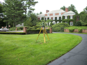
Survey
-

Construction Layout
Construction layout is needed for a variety of different projects including subdivisions, streets, utilities, and multi-story building sites. It can be described as the installation of survey points on the ground to act as a “road map” for constructing site improvements.
-

Specific Purpose Surveys
A Specific Purpose Survey is a unique survey permitted only where unusual conditions make impracticable or impossible the performance of one of the standard types of surveys permitted by the Florida Administrative Code.
-
Res/Com Surveys
Measurement and mapping of your property using mathematics, specialized technology and equipment. Surveys provide crucial information for home buyers and property owners to help you understand exactly what you own and where you may build or improve.
-

Mortgage Surveys
Also known as a Title Survey, a mortgage survey is generally conducted to determine land boundaries and building locations. A relatively simple survey, it will note buildings, sheds, fences, easements and required building setbacks, and natural landmarks.
-
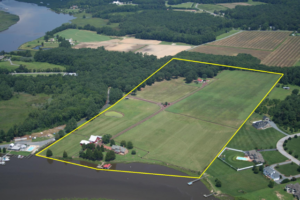
Boundary Surveys
A boundary survey is a process carried out to determine property lines and define true property corners of a parcel of land described in a deed. It also indicates the extent of any easements or encroachments and may show the limitations imposed on the property by state or local regulations.
-

Elevation Certificates
An Elevation Certificate is an important tool that documents your building’s elevation. If you live in a high-risk flood zone, you should provide an Elevation Certificate to your insurance agent to obtain flood insurance and ensure that your premium accurately reflects your risk.
-

As-Build Surveying
As-built surveys are needed to record variations from original Engineering plans to what is actually built. As-built surveys are required by many agencies to prove the location of a structure at a point in time as well as the actual locations of underground improvements.
-

Topographical Surveys
Topographic Surveys are used to identify and map the contours of the ground and existing features on the surface of the earth or slightly above or below the earth’s surface (i.e. trees, buildings, streets, walkways, manholes, utility poles, retaining walls, etc.).